Explorer Expedition Map with Terra Incognita
The frontier map: known territory rendered in careful detail, unknown territory left blank or annotated with speculation, decorative sea monsters and mythical creatures inhabiting the unmapped margins, the edge of known world as visible blank space.
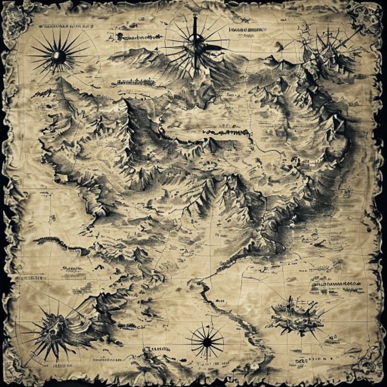
The prompt
Re-render this location as an explorer expedition map from the age of exploration or frontier surveying, rendered in monochrome or light color inks on aged cream or off-white paper stock. Known territory: detailed line-work showing coastlines, rivers, lakes, mountains rendered with hachure shading, established settlements or forts marked with distinctive symbols, routes taken by previous expeditions or explorers shown as marked trails with distance notations and date-markers. Topographic detail: careful drawing of mountain ranges with directional shading, water systems showing current directions and navigability, forest coverage indicated by stippled or symbolic tree-marks. Mapped regions: coastlines rendered with precision at the margin of known territory, with recognized harbors and established trading posts annotated with text-free symbols. Unknown territory (terra incognita): large regions left deliberately blank or annotated with period-style speculation, hatch-marked areas indicating unexplored terrain, question-mark symbols or period notation indicating uncertain geography. Margin decorations: in the blank unmapped regions and sea margins, draw mythical creatures associated with frontier fear: sea monsters (serpents, kraken, whale with exaggerated mouth), exotic animals (fantastical birds, dragons, unknown beasts), and symbolic ornaments (crossed swords, skulls, warnings) rendered as hand-drawn quality illustration. Cartouche: ornate frame in lower corner with expedition title, date, and expedition leader name rendered as text-free decorative block (no legible text). Compass rose: elaborate navigational star, often integrated with decorative elements. Scale bars and distance notations: rendered as text-free marks or period notation. Scale of the map: typically large, showing continental or regional extent. Paper quality: hand-drawn appearance, suggesting original field survey or manuscript origins, aged cream or light tan with foxing and subtle water damage consistent with travel. Preserve the subject, pose, and composition of the source image exactly, change only the medium and rendering.
What it is doing
The expedition map is the frontier as visible fear. Every blank space is a confession of ignorance. The sea monsters in the margin are not decoration, they are the mapmaker saying "here be death." The careful detail at the edge of known territory is the mapmaker's assertion of control, the blank space beyond is the proof of defeat. The map shows what was traveled, what was found, and what remains unknown. The monsters are not scientific notation, they are a warning, an admission that beyond this line the mapmaker has no authority. Explorers brought back drawings and rumors. Cartographers turned drawings and rumors into maps. The monsters were honest. They said: "We do not know what lives here, so we draw fear." The blank space is the most accurate feature of any frontier map.
Tuning knobs
- Frontier-era dial: `Age of Exploration style` (1500s-1600s, sparse European coastal knowledge) vs `19th-century frontier surveying` (North America, Africa, interior mapping) vs `early polar expedition style` (Arctic/Antarctic gaps, speculation at poles)
- Known-territory-detail level: `sparse coastal outline, vast interior blank` vs `comprehensive rivers and settlements, careful interior work` vs `detailed topographic survey, minimal remaining blank`
- Terra-incognita-notation style: `large blank spaces, minimal speculation` vs `hatching or cross-hatching indicating uncertainty` vs `question-mark symbols and period-style annotations`
- Monster-and-margin-decoration intensity: `minimal decorative elements` vs `selective sea monsters and exotic creatures` vs `densely decorated margins with comprehensive creature inventory`
- Line-quality and hand-drawn character: `precise survey line-work` vs `sketched field-notes quality` vs `ornamental hand-calligraphy style with decorative flourishes`
- Expedition-provenance markers: `minimal date and explorer notation` vs `comprehensive dated routes with journey markers` vs `detailed expedition timeline notation and milestone markers`
Style lineage
Learn the visual culture this draws from: Geography Realm.
Related prompts
See all 7 prompts in the Cartography-Operational-Map grammar · Open in the gallery