Celestial Star Chart Planisphere
The night sky mapped as navigable territory: constellation lines connecting bright stars, magnitude notation, ecliptic and equatorial lines rendering the celestial sphere as readable geometry.
The prompt
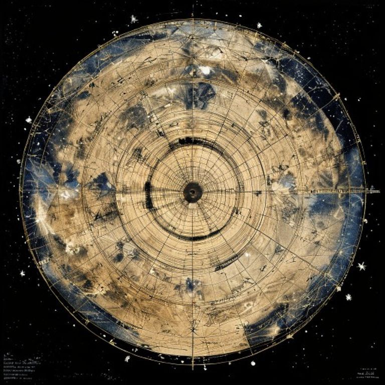
Re-render this location as a celestial star chart or planisphere, the star map used by navigators and astronomers to identify constellations and navigate by the fixed stars. Rendered on cream or off-white stock in black and subtle color inks. Base field: the celestial sphere projected onto a plane, either as a full polar projection (centered on Polaris or south celestial pole) or as an equirectangular band (ecliptic centered, horizon-to-horizon coverage). Star positions: bright stars rendered as filled circles or five-pointed stars sized by magnitude (brightest stars largest, faintest visible stars smallest), positioned according to historical or contemporary stellar coordinates. Constellation lines: fine black lines connecting principal stars of each constellation, forming the classic constellation patterns visible from Earth. Constellation boundary lines: fainter boundaries shown between constellation regions, either as dotted lines or subtle notation. Ecliptic line: the path of the sun through the year, rendered as a bold or colored line passing through zodiacal constellations (rendered as text-free symbols or period notation, no legible names). Equatorial line and celestial equator: reference lines rendered to show the celestial coordinate system. Magnitude scale legend: shown as a series of graduated circles indicating the stellar magnitude system. Grid overlay: fine ruled lines of Right Ascension and Declination for precise stellar position reference. Nebulae and extended objects (Milky Way, major clusters): rendered as subtle shading, stippled regions, or fine dot-patterns indicating celestial clouds and nebulae. Corner notations and title cartouche: rendered as period-style astronomical notation or text-free symbols. Paper stock: aged cream or light blue paper with fine texture suggesting quality astronomical printing. Preserve the subject, pose, and composition of the source image exactly, change only the medium and rendering.
What it is doing
The star chart is the proof that the heavens are legible. Before the chart, the sky was chaos, infinite, divine, untouchable. After the chart, the sky is a coordinate system. Every star is a number. Every constellation is a named vector. The brightest stars are the ones that matter to human navigation. The faintest stars are the ones only specialists know. The planisphere is the assertion that the cosmos is not eternal mystery, it is a solved problem. You hold the chart in your hand and you are no longer lost, you are an astronomer. The night sky that drove ancient humans to terror and wonder becomes a reference document. The fixed stars are the only reliable navigation points on Earth because they are the only things that do not move relative to the observer. The chart turns infinity into a portable object.
Tuning knobs
- Chart-era dial: `classical Ptolemaic constellation arrangement` vs `18th-century astronomical convention` vs `early 20th-century Flamsteed/modern stellar designation`
- Star-magnitude indication: `only bright naked-eye stars` (Mag 1-3) vs `full magnitude range to faint limit` (Mag 1-6) vs `photographic magnitude depth` (faint extended objects included)
- Constellation-line style: `bold clear geometric lines` vs `delicate fine line-work` vs `period-style abbreviated constellation notations`
- Celestial-coordinate emphasis: `polar projection, Polaris centered` vs `equatorial band, ecliptic emphasized` vs `full sphere polar-stereographic projection`
- Nebula-and-extended-object notation: `minimal, stars only` vs `Milky Way band indicated` vs `major clusters and nebulae marked with symbol set`
- Coloring-and-emphasis dial: `monochrome black on cream` vs `constellation lines emphasized in subtle color` vs `color-coded by constellation or magnitude`
Style lineage
Learn the visual culture this draws from: Sky & Telescope.
Related prompts
See all 7 prompts in the Cartography-Operational-Map grammar · Open in the gallery