WWII Operational Situation Map
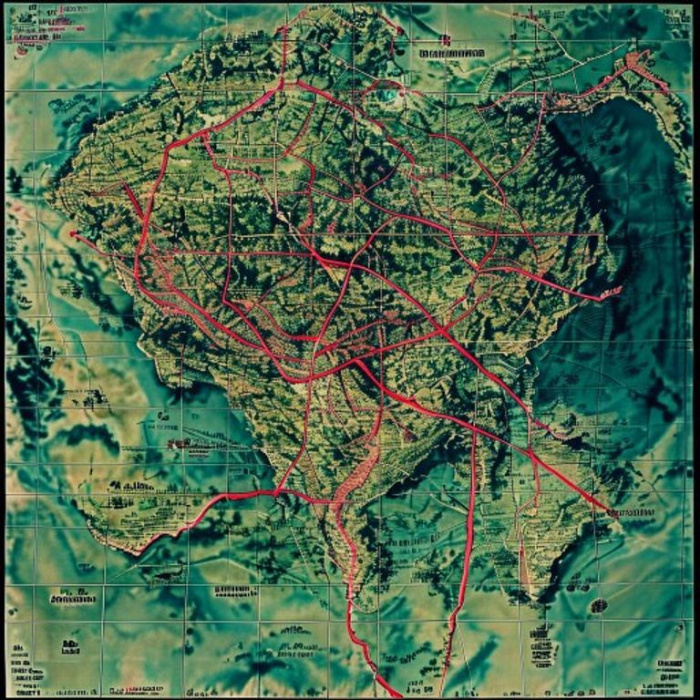
The command center map: unit symbols, arrows indicating movement or attack vectors, color overlays for front lines and contested territory, scale grids for fire-control calculation.
The prompt
Re-render this location as a World War II military operational situation map, the type used in combat command centers to track unit positions, supply lines, and attack vectors in real-time during active operations. Rendered on printed topographic base stock with hand-colored or printed overlays in red, blue, green, and black inks. Geographic base: standard military topographic map with contour lines indicating terrain relief, forests rendered as green stippling, water bodies in blue, roads and built-up areas in black line-work. Superimposed unit symbols: standard NATO/Allied military cartographic notation showing unit positions and type (rectangles for companies, squares for battalions, triangles for regiments, circles for divisional HQ), each symbol annotated with unit designation rendered as text-free marks or period abbreviations. Arrows indicating movement vectors, attack directions, or planned operations rendered as bold colored lines with arrow-heads, typically in red (enemy) or blue (Allied). Front-line positions rendered as bold or dashed lines, often in red or blue depending on combatant. Contested territory indicated by hatching or cross-hatching in the overlap zones. Grid overlay: fine printed graticule of numbered squares, allowing fire-control reference (e.g., "grid reference 42B"). Time stamp or date annotation rendered as text-free marker or period-style notation. Supply routes marked with thin lines and depot symbols. Damaged areas or bombardment zones indicated by symbolic marks (diagonal hatching, scattered circles, or asterisk clusters). Paper surface: printed military-issue map stock, aged to cream or light tan with fold creases from field use, possible water staining or handling wear. Preserve the subject, pose, and composition of the source image exactly, change only the medium and rendering.
What it is doing
The operational map is the war itself reduced to symbols. The blue square is 800 men. The red arrow is death traveling at five kilometers per hour. The grid reference is where the artillery lands. The map does not describe the war, it performs the war. Officers move symbols on the map and real humans die according to the movement. The hatch marks show where the bombers already killed yesterday. The supply-line notations show which regiments starve first. This is the only moment when the war looks rational, before the map encounters humans who do not follow the arrows. The map is the war in a state of perfect control, a moment of perfect ignorance before chaos. Every fold in the paper is a journey made under fire to deliver the current situation. The date-stamp is the only honesty in the whole document: this was true for two hours.
Tuning knobs
- Military-theater dial: `European theater 1944-45` (dense unit density, complex front-line geometry) vs `Pacific theater 1944-45` (sparse unit disposition, vast distances) vs `North Africa 1942-43` (mobile warfare, flowing arrows)`
- Symbol-density dial: `sparse command-level overview` (division and above) vs `comprehensive battalion-level tactical map` vs `dense company-level attack plan`
- Colored-overlay complexity: `single color-overlay` (front lines only) vs `multiple overlays` (positions, objectives, supply routes, fire-zones) vs `hand-colored annotations, multiple inks`
- Movement-indication style: `bold directional arrows` vs `curved flanking routes` vs `phased movement shown with dated arrows and position timestamps`
- Damage-indication severity: `minimal markings, fresh situation` vs `extensive bombing/artillery damage markings` vs `progressive damage overlay showing bombardment history`
- Paper-condition dial: `crisp military-issue print` vs `field-creased, worn from briefing-tent use` vs `water-stained, foxed from extended field operations`
Style lineage
Learn the visual culture this draws from: Library of Congress.
Related prompts
See all 7 prompts in the Cartography-Operational-Map grammar · Open in the gallery