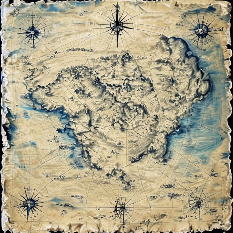
Nautical Chart with Rhumb Lines
The working chart for ocean navigation: rhumb lines radiating from compass roses, depth soundings in fathoms, coastal detail rendered for mariners not historians.
The prompt
Re-render this as a nautical chart in the style of 17th-19th century maritime cartography, produced for use at sea by navigators and pilots. The map rendered in monochrome blue and black line-work on aged cream or light blue paper stock: coastlines rendered as clean bold lines with fine detail (harbors, headlands, river mouths) rendered with precision for practical use. Interior landmass rendered in light wash or stippled shading, subordinate to coastal features. Sea area: densely covered with rhumb lines, a network of radiating lines emanating from multiple compass roses positioned throughout the chart, each rose rendered as a geometric star with radiating directional lines, cardinal directions marked with period lettering (N, S, E, O for Ouest). Compass roses integrated with small secondary roses showing magnetic variation (loxodromic curves rendered as subtle secondary lines). Depth soundings rendered as small numerals scattered across the sea area, indicating water depth in fathoms: place the soundings as text-free marks or symbolic notations (shallow areas marked with sand-grain stipple, rocky areas with small crosses). Navigational hazards: rocks, shoals, and dangerous currents indicated by symbolic marks (crosses, asterisks, small circular clusters). Scale bar shown at the bottom or side of the chart. Paper aged with sepia toning and light staining consistent with ship-cabin use. Preserve the subject, pose, and composition of the source image exactly, change only the medium and rendering.
What it is doing
The nautical chart is the first quantification of the sea. Before charts, the ocean was death, accident, divine wrath. After charts, the ocean was a grid. Rhumb lines are not decoration, they are the assertion that distance can be measured and controlled by geometry. A mariner holds a chart and the sea becomes knowable. The soundings turn water depth into predictable data. The compass roses are not art, they are redundancy: if one gets worn, if one lies, there are others. The chart is not a description of the sea, it is a protocol for surviving it. Every navigator who followed those lines and lived made the next navigator's chart more accurate. The chart is the data compression of thousands of dead mariners.
Tuning knobs
- Chart-era dial: `early Portuguese portolan style` (minimal interior detail, heavy rhumb coverage) vs `18th-century Dutch chart` (precise coastal surveying, systematic soundings) vs `19th-century British Admiralty chart` (comprehensive detail, modern conventions)
- Rhumb-line density dial: `sparse radiating lines, geometric clarity` vs `dense network, overlapping roses` vs `selective emphasis on major trade routes`
- Soundings-coverage dial: `scattered sparse notations` vs `dense soundings throughout coastal zone` vs `systematic grid of soundings with numerical values`
- Coastal-detail level: `minimal, bold outline only` vs `detailed harbors, river mouths, shoal patterns` vs `comprehensive pilot features (anchorages, hazards, landmarks)`
- Color-palette dial: `monochrome black and blue` vs `monochrome with sepia aging` vs `light blue paper stock with brown ink`
- Paper-aging dial: `crisp fresh chart` vs `moderate creasing and fold wear` vs `heavy sepia staining, edge darkening from maritime handling`
Style lineage
Learn the visual culture this draws from: The Geography Hub.
Related prompts
See all 7 prompts in the Cartography-Operational-Map grammar · Open in the gallery